Using a GPS tracker for flight monitoring - Part 1
December 2011 How time has flown since my last post in May this year. In between, the big bird underwent its usual annual inspection and I spent three and a half months redecorating the home. Suffice to say, I didn't get too many flights done during the home duties.
During the home redecoration, I did have time to think about ways to improve the operational safety of my flights. At present, before a flight, I send an SMS message to a pilot friend, nominating a SARTIME. And upon landing, I send another message to cancel the SARWATCH.
If my friend doesn't receive my message to cancel the SARWATCH, he first calls my mobile to check if I just forgot to send the cancellation message. And if he doesn't receive a reply after repeated attempts, he is supposed to alert the relevant search and rescue agencies.
I set up this arrangement with my friend when I first began flying DZY because unlike renting an aircraft from an aviation organisation, private owners flying OCTA have to make their own flight monitoring arrangements. However, there was a weak point which was difficult to address.
When flying within the training area, I'm pretty much near or over populated areas at all times, so someone on the ground is very likely to see an aircraft making a forced landing. However, I often fly outside the Bankstown training area into the Blue Mountains National Park.
The terrain there is not especially favourable for successful forced landings. And with nobody living in a national park, awareness of a downed aircraft is pretty much zero. So even if my friend knows I may be down, nobody has a good idea of where to start searching.
It was with this weakness in mind that I first considered the SPOT and Spider Tracks satellite tracking products. Both are quite impressive products but were a little costly owing to the relatively higher cost of satellite-based messaging (used for transmitting position reports).
While there's no doubt satellite-based position reporting is the best option for operations in remote areas, I think my areas of operation don't warrant use of SPOT or Spider Tracks. So I wondered if GPS trackers using mobile phone networks to relay position reports would be feasible.
To cut a long story short, I bought Meitrack's latest MT90 tracker to test out my idea. It uses the GPS satellite network to obtain positional fixes and GPRS mobile networks (quad band 850/900/1800/1900 MHz) for relaying position reports.
My test unit came from Meitrack China just three working days after I ordered it. The tiny device came in a small box with a lid secured by magnets. Very neat.

Click on photo for a larger image

Note the silicon gasket around the edge of the case for sealing the interior from fluid and dust intrusion.

The MT90 can be configured via SMS message commands or from a PC application via the USB cable link. I found it easier (and free) to use the PC application.
When connected to Meitrack's web-based tracking service via a GPRS network, you can remotely configure the device and also send commands for it to do a wide range of things.
The same can be achieved using SMS messages but of course, this could be expensive if you set the device to send frequent position updates.
After configuration, I ran a static ground test for a Mayday alert. A couple of things followed:
1. A call went out to my emergency contact number (you can pre-program up to three numbers). If answered, normal two-way voice communications (like a mobile phone) commences.
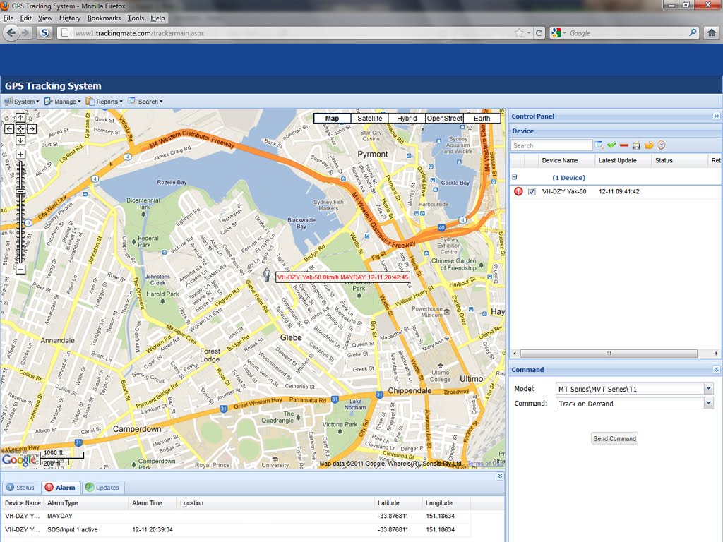
2. A MAYDAY text message was sent to my emergency contact number. The message included a link to Google Maps showing the location of the MT90 tracker.

3. A MAYDAY alert popped up on the Meitrack web tracking screen. And again, the location of the MT90 tracker was shown using Google Maps.
I also tried using the Meitrack tracking service on a small 11.6 inch netbook PC. But I found the small screen made it a little difficult to view the various windows and small text comfortably. It's really best to use a larger desktop PC screen for this sort of activity.
Aside from the regular position reports to the tracking service, the device independently logs your position on the micro-SD card. The data can be downloaded later for replay or track display etc.
Part 2 will involve an airborne tracking test based on a flight out to the Blue Mountains National Park.
Although I'm itching to run the airborne test, the weather is not looking conducive for the next week or so.
Labels: gps tracker, meitrack, mt90
posted by aviatus @ 17:22
0 Comments
![]()
![]()
